Where will the Meadow Be?
Since the orchard was established we have left the grass in the area around the trees to grow longer, while keeping the large central area closely mown.
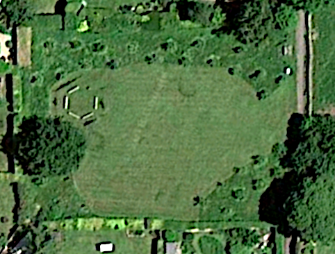
The image below is from Google Maps. The footpath is on the right-hand side and the oak tree and story circle are on the left. The closely mown area in the middle can be clearly seen, in contrast to the longer grass surrounding the trees.
The proposal is that some of this longer grassed area is allocated to the meadow. This is shown on the annotated map below.
The management of the open area in the middle, which has been kept closely mown in the past, will remain unchanged, so that a large area remains for children’s play, picnics and Apple Day activities.
Some paths will be mown through the meadow area and between the meadow area and the hedges.
Four neighbouring properties have gates into the orchard and these will be outside the meadow area. Paths will be mown from these gates into the central area.
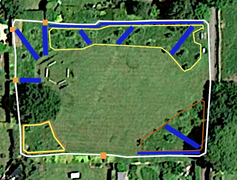
The image above is a map of the meadow development:
-
The white lines are the borders of the orchard, bounded by the hedges and footpath.
-
The four orange dots on the perimeter show the position of gates from neighbouring properties.
-
The yellow-bordered areas on the top edge and in the bottom left corner are the meadow areas.
-
The blue lines show the position of paths that will be mown from the gates, through the meadow area, and between the meadow area and the hedges.
-
The large area in the middle is the existing closely mown area, which will be maintained unchanged.
-
The red-bordered area in the bottom right hand corner has not been agreed with the Parish Council as part of the meadow. It could possibly be added, either in the initial scheme or at a later time if the meadow is considered a success. We would like to know whether including or excluding this area changes your opinion on the project.
With the graphics tool that was used to create the coloured lines above, it is possible to superimpose a grid and count squares to estimate areas. Using this technique, the top meadow area represents 14% of the area of the total site, the bottom left-hand area is 3% and the bottom right-hand area would add a further 8%. Thus the meadow area would be 17% or 25% of the total.
The closely mown area in the middle will remain as it is, and makes up the majority of the site.